Quick links to other relevant pages:
Content on this page:
- Introduction
- How to use
- Tips for entering the pass
- Model data used
- About the FLoating Lab improved model
- Our tidal measurements
Introduction
The passes of the atolls in the Tuamotu exhibit a current which is sometimes incoming, sometimes outgoing, sometimes benign, and sometimes outright dangerous. This depends on multiple factors like the lunar cycle, the tidal cycle and the wind and waves of the preceding days.
Four times a day the current will change direction and there is a (sometimes short) moment where the current is zero: Slack water! Two of these events take place during the night, but two of these should be usable for entering the pass. But how do you know when these slack water moments occur?
The Guestimator is used to "guess/estimate" when the current in passes of Tuamotu atolls is acceptable for passage and/or scuba diving.
The important thing to remember is that the guestimator predictions are just "educated guesses" and can be off especially after unusual weather. Always carefully observe the pass before entering!
The problem
The moment of slack water is not easily predictable for a number of reasons. The current in the pass stops when the water inside the atoll has the same level as the water of the ocean. The water level inside the atoll however depends on the amount of water that has been crashed over the reef during the preceding days. The reef works like a one-way valve: waves from the ocean will slam over the reef, but inside the atoll there are no strong waves so water will never slam back into the ocean but can only exit via the pass. If a lot of water has been crashed over the reef, the water level in the atoll is higher and consequently the moment where the water level equals that of the ocean shifts in time, or may not even been reached at all. To complicate things further, there is no official tidal data for most of the atolls which are sometimes hundreds of miles apart, so data has to be guessed and or composed by careful observations of fellow sailors.
The solution
More than a decade ago, the original Guestimator, which consisted of a set of spreadsheets, was developed. Several people have contributed to it in the past and we are very thankful for that! We were avid users of the original Guestimator and are really happy that it was made. But now the time is ripe for a little upgrade because a set of spreadsheets just isn't the most handy platform for usability, maintenance and refinements anymore. At some point we decided to build our own Guestimator (browserbased + an app for smartphones) with a more accurate model. While the improved model is a long work in progress, we also show the result of the original unaltered Guestimator model, for safety and comparison.
How to use the Guestimator
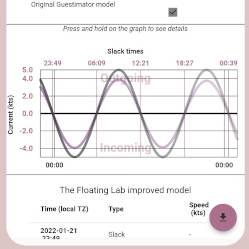
Obviously, you have to tell the Guestimator which pass you would like to enter and on which date. You also have to tell which model(s) you want to use. The resulting graph shows the current, where the line crosses the x-axis there is slack water. The table under the graph gives a small summary of the result.
Wind&Wave factor
The Wind&Wave factor expresses how much water has been blown over the reef inside the atoll during the preceding days. This results in a higher water level in the atoll, and consequently affects the slack time moments. Our Guestimator collects data from meteo.pf to establish this factor, but if you want to do this manually this is also possible. The original Guestimator had these guidelines:
- Add 1 kt for every day the wind has been blowing over 20 kts from a S or W component
- Add .5 kt for every day the wind has been blowing over 15 kts from a S or W component
- Add .5 kt for every 1/2 meter increment of southerly swell over 1.5 meters (ie 3 meter swell = +1.5 kt)
- Cap the Wind Wave factor at 1.5 times the Normal Max Current
- Subtract .5 kt for wide/deep passes and for each extra pass that an atoll has
Our automatic Wind&Wave calculator follows this idea but has some refinements over this:
- The original Guestimator didn't specify for how many days you have to add a factor, but it is logical that older data will have less influence than more recent data. So our automatic Wind&Wave calculator will weigh the factor according to how old the weather report is: It will use four days of weather reports which are accumulated with factors 4-3-2-1 and the result will be divided by 10.
- Instead of using the generic "South or West component" a "wind axis" specific for each atoll is used: some atolls are more sensitive for wind from certain directions.
- With any wind speed over 10 knots it will start to add 0.1 kt for every knot extra wind speed to the Wave&Wind factor. This will give roughly the same numbers but more gradually.
- Passes can also have an additional "negative wind axis", the result being that with wind from that direction the Wind&Wave factor will be negative, i.e. water has blown out of the atoll and there will be more incoming water than outgoing water in the pass. Currently only the Fakarava South pass has a "negative wind axis" (for wind coming from the 135 degree hemisphere).
- A similar approach is used for the Wave Factor, the wave reports are weighed according to age and 0.1kt is added to the result for every 0.1M above 1.5M. Again this gives roughly the same result as the original Guestimator but more gradually.
- Our algorithm does not look at the wave direction. We believe that waves from any direction tend to fill up the atoll.
- Instead of substracting 0.5kt for wide/deep/extra passes each pass has now a "leak factor"; a number between 0 and 1 which is used to multiply the final result. Again, this gives roughly the same result but more gradually and with more control for each individual pass.
The Guestimator can not look into the future! So the automatic Wind&Wave factor will only be calculated for past dates (we will keep the data for at least one month), today and tomorrow (using the today's maritime report).
Tips for entering the pass
Timing is of the essence! The slack time might be earlier than predicted, and in some atolls (especially ones with a high Tidal Amplitude) it may be short. So make sure to arrive early. Watch for signs of standing waves in the pass. Do not enter if you see high waves in the pass. It might be handy to have a working log (the difference with the GPS speed will reveal the current when you approach the pass) so clean out the critters when you plan to go through a pass.
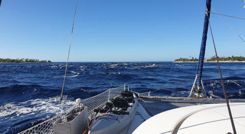
Beware of standing waves, we've seen a picture of a 50+ ft mono that capsized in a pass with standing waves. Luckily it turned upright again but they did take a lot of ocean water inside the boat...
It is best to go through the pass during slack time, but there might be reasons to attempt to enter the pass outside of this small window, like lack of available daytime, approaching bad weather, or there might simply not be a slack time at all. In our experience it is safe to try to enter a pass (from the outside) when the tide is outgoing and there are no standing waves. If you don't like the situation in the pass, you just have to throttle back to slowly drift out again. Never turn around, just throttle back so the current will take you out but make sure to maintain enough power to keep the boat steerable. Be aware that the worst conditions are when you have wind against current. Luckily, most passes are on the West of the atolls and the wind is usually coming from the East, so with outgoing current you usually have the wind with the current. Be aware also that at the end of the pass (as seen from the outside) there might be sudden currents coming from "canals" on the sides. Prepare your entry, have some idea where to steer once you are at the end of the pass.
Going out of the atoll it is usually safe to go with the outgoing tide, but do this only when the wind is with the current. Be aware that once inside the pass you probably have no other option than to continue the ride no matter what, so do this only if you are familiar with the pass. You might log some interesting speeds, but do not throttle back. You need to maintain a positive speed above the current to keep the boat steerable. When in doubt, just wait for slack time.
Model data used
- Model data verified
- We strive to verify the pass data of each Tuamotu pass by observation and/or a special measurement buoy. When this is done, we flag the model data as being "verified". We haven't visited each atoll (yet), so much of the data is based on the original Guestimator data, which we consider as "unverified" for a number of reasons.
- Rangiroa offset
- This is our most important number: it determines the point in time when slack water occurs (without wind and wave factors). It is a complex number based on the Rangiroa tidal table, the Hao tidal table, the observed tidal shift, and the slack delay which depends on the ratio between the volume of the atoll and the volume of its passes.
- Tidal amplitude
- This is our second most important number: it describes the average maximum current between two adjacent slack times, without correction for lunar cycle. It was named "Max Tidal Current" in the original Guestimator but it is a bit confusing as the current can actually be more than this due to Tidal Amplification and Wind&Wave factors.
- Tidal amplification
- The tides are not the same every day but depending on the lunar cycle. We use the official published tidal data from Rangiroa to determine the ratio between the lowest and highest water level of a particular cycle and use this as an amplification factor for the pass current. In simple words: If the difference between low and high tide is twice as much compared to another day, it is safe to assume that the current will be also twice as high. After all, it is the difference between low and high tide which drives the current. Note that this tidal amplification not only affects the current, but also the slack water moment when the graph is "lifted" due to a Wind&Wave factor.
About The Floating Lab Improved model
Some notable changes in The FLoating Lab Improved model:
- Tidal amplification
- The original Guestimator lacked a tidal amplification, which is a correction on the pass current depending on the lunar cycle. This not only affects the current but also the moment when slack water can be expected. The result is that the predicted current in the pass might be noticeably stronger during new and full moon than shown in the original Guestimator, and noticeably weaker at other times. It also "compresses" the out-to-in and in-to-out slack water moments when a wind&wave factor is applied. All this matches perfectly with our own observations after sailing some years in the Tuamotu.
- Tidal offset
- Unfortunately there are no individual tidal tables for each single atoll. There is only a table for Rangiroa and for Hao and strangely their timings are some 2:18 hours apart. This is quite a lot, purely based on longitude the difference should be less than 30 minutes (there is only about 6.5 degrees difference in longitude between these two tidal stations). In the original Guestimator somebody "corrected" the timing to 1:18 (suggesting there was "a time zone problem") which is still a very large difference. Nevertheless the guestimator interpolates all the other atols between Rangiroa and Hao based on their longitude relation to these two tidal stations. If you look closely to the tables, during full moon Hao has the high tide close to noon and midnight as it should be, but Rangiroa is quite far off. It looks like Rangiroa is the actual oddball here. And after careful checking it looks like the published tidal difference between Rangiroa and Hao is indeed 2:18 hours (and the "correction" by one hour is based on a false assumption). Interestingly the slack water moment of Hao is further corrected by a whopping 180 minutes of "tidal slack delay". The large difference between Rangiroa and Hao and the arbitrary corrections made me suspicious about the validity of interpolating between two questionable tidal tables. This led to some attempts to measure and verify the tidal offsets for each atoll individually.
- Maintenance
- You don't have to download new versions with updated tidal tables anymore, the Guestimator will take care of that in the background. If new data becomes available about specific passes, it will automatically show up in the Guestimator.
Our tidal measurements
As luck would have it, my son Thomas who is a physics student was here for a month around christmas/new year, and he got interested in my tidal questions. He came up with a simple but elegant solution to log the data from our depth sounder (whose NMEA-stream is conveniently available on our boat WiFi network) and derive the tidal movements from this. I was sceptical about this (waves, bommies, changes of heading and thus sea bed height) but with some fourier transformations it worked surprisingly well. With this we could confirm that the Fakarava data was not very far off, however we also realised that this didn't guarantee the pass currents to match exactly with this data without a secondary confirmation.
Ideally, we would have to find the moment when the current is on its peak, but this is not easy to do. There is an easier way by observing the slack water moments, but they are variable because of Wind&Wave factors: If the water level in the atoll has rised due to waves crashing over the reef, it takes longer before the rising sea level matches the water level inside the atoll (and thus slack time occurs later during rising tide) and when the tide drops the water inside the atoll starts to flow out earlier. The center between these two slack time events however keep a stable relation to our tidal reference table, regardless of Wind&Wave factors. If this dazzles you, you can easily see this if you play with the "wind/wave factor" in the Guestimator: the slack times start to change but the high and low time remain stable. Anyway, to cancel out any Wind&Wave effects we only need to collect multiple exact slack water moments and derive the moments of maximum current (high tide) from these and compare them to the tables to find the true tidal offset.
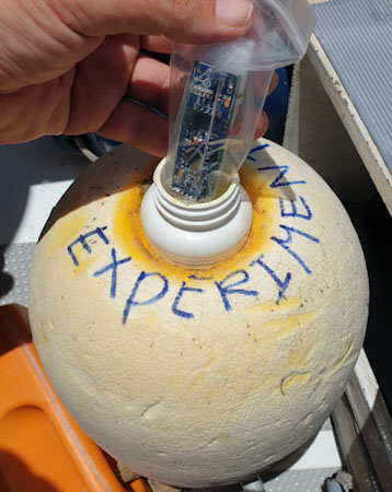
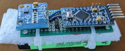
But how do you that? Not only is this a tedious job (unless anchored in the pass itself) but half of the measurements would have to take place during the night, especially since you need to collect a complete pair of slack water events to cancel out the Wind&Wave effect by determining their center. So this is when I started to think that an automated tidal direction aggravation device would be handy to deploy. Well, like every modern sailor I just happen to have a bag of some cheap Arduino microprocessor boards and some magnetic sensors on board and that is all that is needed to devise some kind of buoy that swings orientation when the current direction changes and records these changes of magnetic heading into the EEPROM of the microprocessor.
To write some logging software was trivial once I understood how to interpret data from the magnetic sensor, all that was left was to assemble some parts together. Because I wanted the logging buoy to keep working for multiple days I had to reduce the power consumption of the microprocessor. After taking out the LED's, power regulator and reducing the clock cycle of the processor, it could run for days on a small rechargeable lithium battery.
The buoy itself is just one of these things you will sadly find everywhere on the beaches, and after some modifications it was ready for its new nerdy task. The buoy is attached to its anchor via the aluminium "arm" mounted on the buoy (on the left in the picture) which is essential to make it swing in the direction of the current. We enlarged the hole on the top so we could fit a plastic bottle inside which contains our data logger. Another bottle filled with sand (the orange one in the picture) is tied to the bottom, to keep the good side up and to make it a bit more stable in the waves.
After a few days we pick up the buoy to read out the recordings and match them with the Guestimator predictions.
Lots of effort goes into the free information pages and services of this website. If you want to show your appreciation and support my efforts, you are welcome to contribute with a donation to my personal Paypal account.
